673285
Holderness Coast
- LOCATION
- North east of Britain's
coast.
- next to the north sea
- near the river humber. which passes through hull
- County of
Humberside
- North east of Britain's
coast.
- PROCESSES
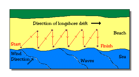
- Long Shore Drift.
- long shore drift is the movement of
material along the beach in a zigzag
pattern
- long shore drift is the movement of
material along the beach in a zigzag
pattern
- Hydraulic Action
- the force of the waves against the coastline/cliffs can cause air to be
trapped in crakcs and crevices. the airpressure weakens the cliff and it
slowly starts to collapse
- the force of the waves against the coastline/cliffs can cause air to be
trapped in crakcs and crevices. the airpressure weakens the cliff and it
slowly starts to collapse
- Coastal Erosion
- coastal erosion is the wearing away of land and the
removal of beach or dune sediments by wave action, tidal
currents and wave currents
- coastal erosion is the wearing away of land and the
removal of beach or dune sediments by wave action, tidal
currents and wave currents
- Long Shore Drift.
- A costal environment (small-regional
scale): the processes affecting this coast,
its landforms and the management
- LANDFORMS
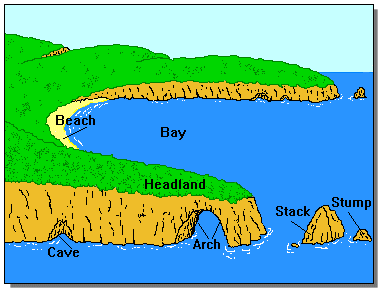
- erosional landforms
- Crack - Cave - Arch - Stack - Stump
- Crack - Cave - Arch - Stack - Stump
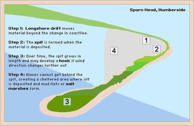
- Spurn Head Spit
- a spit is made from deposition. 1. waves come in at an angle and
so the swash washes the sediment up the beach at an angle. 2.
gravity makes backwash and carries it down the beach at right
angles (long shore drift). 3. forms a long extended beach. 4. the
second most usual wind pushes the end round which then creates
a hook
- erosional landforms
- MANAGEMENT
- Sea Walls
- big tall blocks of concrete with a
small curved over top to deflect
water
- stops the sea bashing into the
coastline and eroding it away.
- big tall blocks of concrete with a
small curved over top to deflect
water
- Groynes
- Wooden fences built at a
right angle to the
coastline
- aim to stop the movement of material
along the beach due to long shore
drfit
- Wooden fences built at a
right angle to the
coastline
- Rock Armour
- large boulders of 10 tonnes or more
are used as a sea wall or as stone
groynes.
- the gaps between the rocks allow water through,
which means that the energy of the waves is
reduced before hitting the coastline
- large boulders of 10 tonnes or more
are used as a sea wall or as stone
groynes.
- Sea Walls
- LANDFORMS
Media attachments
Want to create your own Mind Maps for free with GoConqr? Learn more.