85337
Description
Flashcards by daminigrover, updated more than 1 year ago
|
|
Created by daminigrover
over 11 years ago
|
|
| Question | Answer |
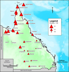
| Proportional-Symbol thematic maps | |
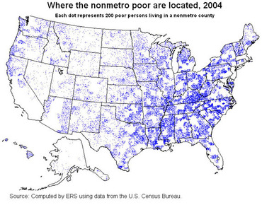
| Dot Density Maps |
Image:
dot_density_map (image/jpg)
|
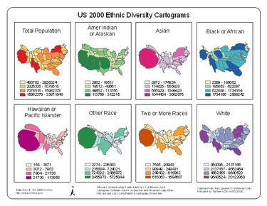
| Cartogram | |
| Data Aggregation | The size of geographic units being represented on a map. |
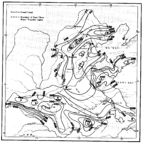
| Isoline thematic maps |
Image:
80157E0T.GIF (image/GIF)
|
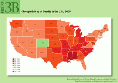
| Choropleth thematic maps |
Image:
Choropleth_map (image/png)
|
| Intermediate Directions | Northwest, Northeast, Southwest, Southeast |
| Relative Directions | right, left, up, down |
| Equal-Area projections | maps that maintain shape but distort other properties (it is impossible to have a projection that is both conformal and equal-area). |
| Azimuthal projections | maps that maintain direction but distort other properties. |
| Equidistant projections | Maps that maintain distance but distort other properties. |
| Cognitive maps | Maps drawn from memory. |
| Reference maps | Maps that show common features such as boundaries, roads, highways, mountains and cities. |
| Thematic map | Maps that zeros in on one feature such as climate, city size, etc. |
| Isoline thematic maps | Maps that display the lines that connect points of equal value, showing elevation levels. |
| Choropleth thematic maps | Maps that show a pattern of some variable, such as population density, voting patterns, etc. |
| Proportional-Symbol thematic maps | Maps that uses a symbol to represent the frequency of a variable. |
| Spatial Perspective | A way of identifying, explaining and predicting the human and physical patterns in space and the interconnectedness of various spaces. |
| Dot Density Maps | Thematic maps that use dots to represent the frequency of a variable. |
| Cartogram | Map that uses proportionality to show a particular variable. |
| Geographic Models | Simplified versions of what exists on the earth and what might exists in the future. |
| Geographic Information System (GIS) | A computer program that stores geographic data and produces maps to show those data. |
| Physical Geography | Concerned with spatial analysis of the structures, processes and locations of the earth's natural phenomena. |
| Remote Sensing | The collecting of information from satellites and distant collecting systems. |
| Primary Data | Information that is collected for the first time; used for solving the particular problem under investigation |
| Human Geography | Primarily concerned with analyzing the structures, processes and locations of the earth's human creations and their interactions. |
| Secondary Data | Data collected by someone else and presented to the public for future use. |
| Absolute Location | refers to a position on the global grid |
| Lines of Latitude | imaginary lines that run east and west, they tell how far north and south of the equator (also called parallels) |
| Lines of Longitude | imaginary lines that run north and south on map or globe, they tell how far east and west of the prime meridian ( also called meridians) |
| Great Circles | Circles formed on the earth's surface by a plane that passes through the center of the earth. |
| Relative Location | Its location as described in relation to places on the earth's surface |
| Site | A place's internal, physical and cultural characteristics. |
| Situation | Refers to location (or context) of a place, relative to the physical and cultural characteristics around it. |
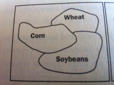
| Formal Region (uniform region) |
Image:
image_3 (image/jpeg)
|
| Formal Region (uniform region) | Areas that have common (or uniform) cultural or physical features. |
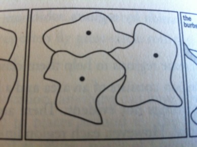
| Functional Region (nodal region) |
Image:
image_2 (image/jpeg)
|
| Functional Region (nodal region) | A group of places linked together by some functions influence on them. |
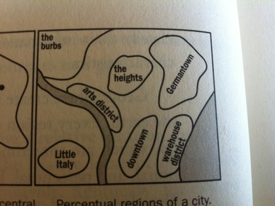
| Perceptual Region (vernacular region) |
Image:
image (image/jpeg)
|
| Perceptual Region (vernacular region) | The boundaries of this region are determined by belief. |
| Region | Spatial units that share some similar characteristics. |
| Place | A unique combination of physical and cultural attributes that gives each location on earth its individual "stamp". |
| Sense of Place | A person's perception of the human and physical attributes of a location that gives it a unique identity in our minds. |
| Spatial Interaction | How places interact through movement. |
| Friction of Interaction | The degree to which distance interferes with some interaction. |
| Space-time Compression | The increasing sense of accessibility and connectivity seems to bring humans in distant places closer together. |
| Distance Decay | Interaction between two places declines as the distance between two places increases. |
| Map | Two-dimensional model of the earth or a portion of its surface. |
| Cartography | The process of mapmaking. |
| Simplification | When a cartographer gets rid of unnecessary details and focuses on the information needing to be displayed in the map. |
| Simplification | When a cartographer gets rid of unnecessary details and focuses on the information needing to be displayed in the map. |
| Distortion | An error which occurs when the earth is flattened on to a two-dimensional surface |
| Four Main Map Properties | -shape -size (area) -distance -direction |
| Cardinal Directions | North, East, South, West |
Want to create your own Flashcards for free with GoConqr? Learn more.