Description
|
|
Created by eimearkelly3
over 11 years ago
|
|
Page 1
Plate tectonics is the study of the processes that cause the movement of the earth's plates and the landforms that result.
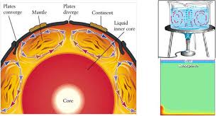
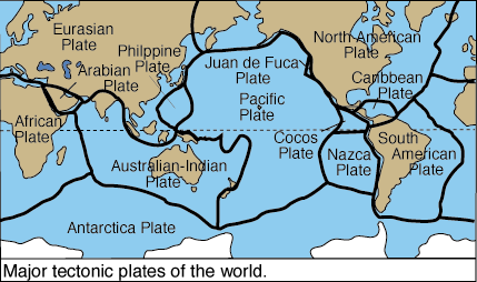
The theory suggests that the earth's crust is broken into segments called plates. There are 7 large and several minor plates. The plates are in continual slow motion around the globe. The massive convection currents within the asthenosphere drive the motion. As the plates move, so too do the earth's continents and oceans.
How convection currents workHeat from the core transfers to the mantle.The mantle becomes semi-molten (and therefore lighter) and it rises towards the crust.Here it cools and sinks again.Therefore the magma is moving in circular motion. These movements are known as thermal convection currents.The movements move the plates which float on top.
Sea-floor spreadingHarry Hess-1960sSuggests that the ocean floors widen as new rock is formed where the plates have split apart. Convection currents fuel the seperation of the plates. As they seperate, magma rises from within the mantle and fills the opening made. As this magma cools, a new crust is formed. With further magma cooling over time, further new crust is formed and older crust moves away from the centre.Proof: The different magnetisms in the rocks either side of the mid-ocean ridge match up. The sea floor is youngest at the mid-ocean ridge and older further away from it. Deposits of sediment following glaciation are found where the continents were once joined together. Young volcanic islands are found near the ridge with older volcanic islands being found further away from it.
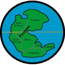
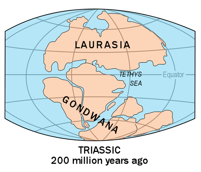
Continental driftAlfred Wegener 1912Suggests that the continents are transported across the planet by convection currents. The continents were once joined together in a single landmass (supercontinent) called PANGAEA surrounded by an ocean called Panthalassa. Approximately 200 million years ago Pangaea started to break apart. The continents, fuelled by convection currents, began to drift apart. Initially the supercontinent broke into two major sections called Laurasia and Gondwanaland.Proof: The edges of the continents fit together like a jigsaw puzzle e.g. the east coast of South America and the west coast of Africa. The same type of fossils have been found in South America and Africa meaning that these two continents were at on stage joined together. (distribution of identical fossils around the world). MESOSAURUS REMAINS found in both southern Africa and Eastern South America. Matching mountain trends and rock types on continents seperated by thousands of mile of sea e.g. Scandinavia and the Appalachians in the USA.
Divergent/constructive plate boundaries Convergent/destructive plate boundaries Conservative/passive plate boundaries
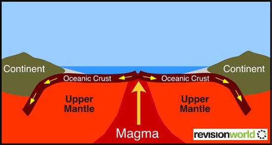
Constructive plate boundaries-plates are seperating/diverging e.g. North American & Eurasian South American & African
Heat from the core transfers to the mantle, the manlte becomes semi-molten and convection currents form. Convection currents cause two plates to seperate, the lithosphere will split apart to produce a rift valley e.g. The East African Rift Valley. Molten magma rises and fills the gap between the two plates, this will create a new sea floor (sea-floor spreading) e.g. The Red Sea. As molten magma rises it forces the crust upwards to form a mid-ocean ridge (e.g. The Mid-Atlantic Ridge where the North American and Eurasian plates seperate). These ridges rise several thousands of meteres from the ocean floor. As the magma wells upwards some esapes onto the ocean floor giving volcanic activity. These eruptions tend to be from long cracks (fissures) rather than a central vent. The magma hardens adding to the height of the ridge, in some places building above the level of the water, forming new land, e.g. Iceland. The seperation of the plates gives rise to low magnitude earthquake activity. (Shallow earthquakes).
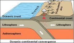
Destructive plate boundaries-plates are colliding e.g. Nazca & South American forming the Andes
The heavier oceanic plate dips under the lighter continental plate. It sinks into the mantle in a process known as subduction. This forms a deep ocean trench. Sediments that are carried on the seabed of the subducting plate are scraped off and pile up against the edge of the continent, forming fold mountains. These sediments form unique geological areas known as terranes. As the oceanic plate begins to melt (at a depth of about 80km) some of the melting magma may rise through the rock above it (less dense and has a high silica content) to reach the surface and form a volcano e.g. Mt. St. Helen's in the Rockies. The sinking plate grinds into the mantle in a jerky movement which gives rise to earthquake activity. (Deep earthquakes) This may displace the water above it and cause a tsunami. As the oceanic plate sinks the continental plate will be forced to buckle and fold into fold mountains e.g. The Andes
Oceanic-oceanic --> one plate subducts under the other to form a deep ocean trench. e.g. the Mariana Trench where the Pacific plate subducts underneath the Philippines plate (deep earthquakes). The sinking plate melts creating rising bubbles (plumes) of magma that break through the crust above. The melting magma may rise to build up and form a curved line of volcanoes called a volcanic arc e.g. Japan
Continental-continental --> plates collide, buckle, and fold to form fold mountains such as the Himilayas (Eurasian and Indo-Australian). This can cause shallow earthquakes e.g. Pakistan 2005. These mountains continue to rise at a rate of approx. 2.5cm per year.
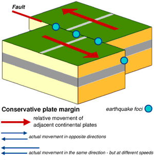
Conservative plates boundaries-plates are sliding parallel to eachother (transform/transverse faults) e.g. the Pacific & North American platesThe Pacific (moving NW at 6cm/annum) and North American Plate (moving NW at 1cm/annum) forms the San Andreas fault line. Cities such as San Francisco and Los Angeles are affected by this fault line.
At this boundary, to plates are mvoing parallel to eachother so crust is neither created nor destroyed. As the plates are kilometres thick, the rock within the plaes tends to grind against eachother as they pass. The plates may become stuck. Pressure will build up so these rocks stretch up to a point and will eventually snap (elastic rebound). The pressure is released causing seismic activity. The movement is often referred to as 'slip-stick-slip' movement. A line where plates are sliding past is a faultline and such areas are extremely prone to earthquake activity. It is impossible to predict when pressure will be released/rocks will snap. e.g. Haiti 2010 earthquake on the boundary between the Carribean and North American plates.
Facts
Plate boundaries
Videos
Want to create your own Notes for free with GoConqr? Learn more.