553502
Description
Quiz by Toni Gahn-Black, updated more than 1 year ago
|
|
Created by Toni Gahn-Black
almost 11 years ago
|
|
Question 1
Question
Which of the following best describes the current emphasis in the field of physical geography?
Answer
-
studying climates
-
tracking changes in the world’s biodiversity
-
collecting and cataloguing facts about natural phenomena on the earth
-
understanding how Earth’s systems interact to produce natural phenomena
Question 2
Question
Geography is described as
Answer
-
a physical science
-
an Earth science
-
a human science
-
a spatial science
Question 3
Question
Which of the following correctly describes the behavior of a system with positive feedback?
Answer
-
It will not respond at all to a change of input.
-
It will respond to a change in input by moving further from its equilibrium condition.
-
It will respond to a change in input moving towards its equilibrium condition.
-
There is not enough information to tell because we do not know the nature of the system components.
Question 4
Question
Which of the following comes first in the scientific method?
Answer
-
development of governing laws
-
predictions
-
observation
-
development of a hypothesis
Question 5
Question
Which of the following most accurately characterizes the goal of geography?
Answer
-
understanding why a place has the characteristics that it does.
-
memorization of the imports and exports of a country
-
the production and analysis of maps
-
memorization of the names and places on world and regional maps
Question 6
Question
Which of the following best describes the value of a theory in the scientific method?
Answer
-
It has little value because it is "just a theory".
-
It always represents a negative feedback in the process.
-
It stimulates continued observation and testing.
-
It represents established and unquestionalble fact.
Question 7
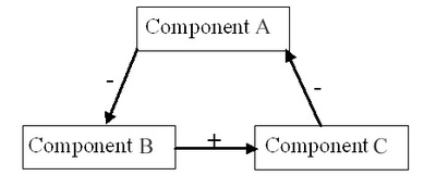
Question
In the system diagram above, if Component A increases, what will happen to Component C?
Image:
Feedback_loop (image/jpeg)
Answer
-
It will not change.
-
It will decrease.
-
It will increase.
-
It will explode.
Question 8
Question
In the system diagram, if an initial input to the system causes component A to increase, what will happen to component A after the input has traveled through the system one time?
Image:
Feedback_loop (image/jpeg)
Answer
-
It will change in the same way as component C.
-
It will increase further.
-
It will decrease.
-
It will not change.
Question 9
Question
In the system diagram, what is the term for the relationship between Component A and Component B?
Image:
Feedback_loop (image/jpeg)
Answer
-
a negative feedback
-
a positive coupling
-
a positive feedback
-
a negative coupling
Question 10
Question
Which of the following is incorrect?
Answer
-
Earth represents a vast interconnected system.
-
Earth represents a closed system in terms of matter.
-
Earth is constantly receiving new resources and matter.
-
Earth represents an open system in terms of energy.
Question 11
Question
When a system suddenly jumps to a new equilibrium level, we say the system has reached
Answer
-
a feedback loop.
-
an equilibrium shift.
-
a threshold.
-
an input.
Question 12
Question
The scientific method includes both positive and negative feedback.
Answer
- True
- False
Question 13
Question
Which of the following terms best identifies the focus of physical geography?
Answer
-
geosystems
-
the biosphere
-
ecosystems
-
the ecosphere
-
the lithosphere
Question 14
Question
In the lake system diagram, if an input to the system causes lake level to increase initially, what will happen to the lake level after the input has traveled through the system one time?
Image:
lake_systems (image/jpg)
Answer
-
It will decrease.
-
It will increase further.
-
It will not change.
-
There is not enough information to tell.
Question 15
Question
In the lake system diagram, if shoreline distance decreases, what will happen to lake surface area?
Image:
lake_systems (image/jpg)
Answer
-
It will stay the same.
-
It will reach steady-state equilibrium.
-
It will decrease.
-
It will increase.
Question 16
Question
What type of feedback is represented by the lake system diagram example?
Image:
lake_systems (image/jpg)
Answer
-
negative feedback
-
both positive and negative feedback
-
positive feedback
-
There is not enough information to tell.
Question 17
Question
Which of the following represents a body of facts that is specific to geography?
Answer
-
landforms
-
climate
-
political systems
-
settlement patterns
-
None of these; geography is governed more by method and approach than a specific body of facts.
Question 18
Question
With regards to matter, Earth can be essentially considered
Answer
-
a closed system
-
an infinite system
-
a non-equilibrium system
-
an open system
Question 19
Question
What is the usual result of the scientific method?
Answer
-
a need for continued observation and testing
-
an established set of unquestionable facts
-
a bunch of numbers
-
new knowledge
-
both new knowledge and a need for continued observation and testing.
Question 20
Question
The scientific method should be seen as a sequence with distinct starting and ending points.
Answer
- True
- False
Question 21
Question
Which of the following statements would best describe the emphasis in college-level geography in the United States?
Answer
-
Geography primarily studies the physical aspects of the Earth's surface.
-
Geography's main emphasis is on spatial arrangement and the explanationof why things are where they are.
-
Geography puts its greatest emphasis in learning where places are located.
-
Geography is basically a technical field primarily concerned with map-making.
Question 22
Question
Because geography uses elements from both the physical and human systems to explain the spatial distribution of various phenomena, we can call geography a(n) ___________ science.
Answer
-
social
-
humanistic
-
integrating
-
natural
-
physiographic
Question 23
Question
Which of the following best describes physical geographers' current interest in human features and processes across the Earth?
Answer
-
They are strongly focused on human features or processes.
-
They are interested in the interactions between physical and human features and processes.
-
They are not concerned with human features or processes.
-
They are only interested in how physical features and processes control or limit human features and processes.
Question 24
Question
What is the generic term for any line that connects points of equal value on a map?
Answer
-
a legend
-
an isopoint
-
a rhumb line
-
a projection
-
an isoline
Question 25
Question
Which of the following representative fractions represents the largest scale?
Answer
-
1:50,000
-
1:1,000,000
-
1:24,000
-
1:10,000
-
1:100,000
Question 26
Question
Which of the following would be used for overlay map analysis where two or more map layers are superimposed or integrated?
Answer
-
GOES
-
GPS
-
GIS
-
Landsat
-
AVHRR
Question 27
Question
Most of the United States is located between which of the following pairs of parallels?
Answer
-
the Arctic Circle and the Tropic of Cancer
-
the Tropic of Cancer and the equator
-
the equator and the Tropic of Capricorn
-
the Tropic of Capricorn and the Antarctic Circle
Question 28
Question
Which of the following is an example of remote sensing?
Answer
-
advanced very high resolution radiometer
-
radar
-
infared satellite imagery
-
an aerial photograph
Question 29
Question
Commercially available global positioning system receivers can currently be used to determine location to an accuracy of
Answer
-
1 degree
-
10 meters or less
-
100 meters
-
1 kilometer
Question 30
Question
Which of the following would be most likely to be portrayed on a very large-scale map?
Answer
-
continents and oceans
-
mountain ranges
-
individual streets in a town
-
time zones
Question 31
Question
Which of the following terms best describes the shape of the Earth?
Answer
-
a sphere
-
an egg
-
a geoid
-
an eratosthenoid
Question 32
Question
Which of the following accurately describes the commonly used Mercator projection?
Answer
-
equivalent
-
conformal
-
cylindrical
-
conic
-
both conformal and cylindrical
-
all of these
Question 33
Question
If you are making a map that is likely to be photocopied and enlarged or shrunk by users, which type of scale would be best to include on your map?
Answer
-
a ratio scale
-
a conformal scale
-
a written scale
-
a graphic scale
-
a fractional scale
Question 34
Question
What is the term for the property of equal area on a map?
Answer
-
cylindrical
-
equivalence
-
azimuthal
-
parallel
-
conformality
Question 35
Question
It is much easier to minimise distortion on a small-scale map.
Answer
- True
- False
Question 36
Question
If it is 6:00 a.m. Monday in Tokyo (140 degrees E Longitude), what time is it in Rio de Janeiro (40 degrees W Longitude)?
Answer
-
6:00 p.m. Monday
-
6:00 p.m. Tuesday
-
6:00 p.m. Sunday
-
6:00 a.m. Sunday
Question 37
Question
0° Longitude is also known as
Answer
-
the Prime Meridian
-
the International Date Line
-
the North Pole
-
the equator
-
the Tropic of Cancer
Question 38
Question
Which of the following is true regarding lines of latitude?
Answer
-
They are parallel to each other.
-
They run north to south.
-
They are used in measuring time changes.
-
They range from 0° to 180°.
-
They are called meridians.
Question 39
Question
Which of the following is true regarding time zones?
Answer
-
They are 15 degrees wide because Earth rotates through that distance in one hour.
-
They are split approximately down the middle by a central meridian.
-
They are based on distance from Greenwich, England.
-
all of these.
Question 40
Question
A scale given as "one centimeter to one kilometer" is an example of which type of scale?
Answer
-
written
-
conformal
-
graphic
-
representative fraction
-
equivalent
Question 41
Question
Which of the following features would prove most difficult to map if the cartographer desired to preserve features of both equal area and true shape?
Answer
-
a city
-
Australia
-
North America
-
a bike trail through a park
Question 42
Question
Suppose that it is 11:30 p.m. Tuesday immediately west of the International Date Line. What is the time and day immediately east of the International Date LIne?
Answer
-
11:30 p.m. Monday
-
11:30 p.m. Tuesday
-
11:30 a.m. Monday
-
12:30 a.m. Monday
-
11:30 a.m. Tuesday
-
12:30 a.m. Tuesday
Question 43
Question
Suppose that it is 12:30 a.m. Wednesday immediately west of the International Date Line. What time is it immediately east of the International Date Line?
Answer
-
12:30 a.m. Monday
-
11:30 p.m. Monday
-
11:30 a.m. Tuesday
-
11:30 p.m. Tuesday
-
12:30 a.m. Tuesday
Question 44
Question
Which of the following features are typically represented on topographic maps?
Answer
-
elevation
-
rainfall
-
atmospheric pressure
-
wind
-
all of these
Question 45
Question
Which of the following is a capability of a geographic information system?
Answer
-
data storage
-
data manipulation and analysis
-
map production with different information layers
-
electronic visualization of spatial analyses
-
all of these
Question 46
Question
The larger the scale of a map, the ______ the extent covered by the map and the _____ detail it provides.
Answer
-
larger; less
-
smaller; more
-
larger; more
-
smaller; less
Question 47
Question
Which of the following represents all Earth properties of area, shape, direction, proximity, and distance correctly?
Answer
-
Alber's equal-area conic projection
-
Mercator projection
-
Robinson projection
-
an oval projection
-
a world globe
Question 48
Question
Satellite images are based on
Answer
-
signals compiled by geographic information systems
-
digital data that are stored electronically and then transmitted to Earth by radio waves
-
signals compiled by global positioning system receivers
-
standard photographic film that is recovered after a satellite returns to Earth
-
holographic images created from laser-generated interference patterns
Question 49
Question
Earth's equator is an example of
Answer
-
a small circle
-
a prime meridian
-
a great circle
-
a line of longitude
Question 50
Question
Which of the following represents an application of global positioning systems?
Answer
-
ocean navigation
-
tracking changes in the elevation of mountains
-
backpacking
-
research in physical geography
-
all of these
Question 51
Question
If you are making a map that is likely to be photocopied and enlarged or shrunk by users, which type of scale would be best to include on your map?
Answer
-
a graphic scale
-
a written scale
-
a ratio scale
-
a fractional scale
-
a conformal scale
Want to create your own Quizzes for free with GoConqr? Learn more.