Description
|
|
Created by eimearkelly3
over 11 years ago
|
|
Page 1
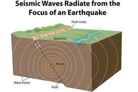
Earthquakes are vibrations or tremors in the earth's crust that are cause by the sudden release of energy along a fault line.The seismic waves or tremors are known as shocks. The largest shock is called the main shock, the shocks before, the foreshocks, and the shocks after the aftershocks.Shock waves or tremors travel out from the origin or focus of the earthquake. The site directly above the focus, on the surface, is known as the epicentre. Most damage is done here.As the plates settle back to their normal positions after the earthquake (elastic rebound) more earthquakes, or aftershocks, can occur. These can do more damage to already weakened buildings and send panic through affected populations.
Causes of an earthquake: Plate movement is fuelled by convection currents in the molten magma. The plates move slowly and sometimes get stuck. When this happens, stress and pressure build up in the rocks of the plates. The rocks bend under this pressure and eventually the plates slip along the fault line. The energy is then suddenly released, similar to the effect of the snapping of a taut elastic band. This sends shock waves to the surface, resulting in an earthquake. Glaciers are huge masses of ice. When glaciers are intact, they exert a lot of pressure on the area of the Earth's surface that they cover. When the glaciers melt, the pressure is released. This can cause earthquakes. Fault lines becoming active again can also cause earthquakes.
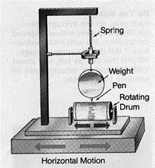
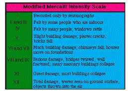
Earthquake measurement:A seismometer / seismograph is the instrument used to measure and record earthquakes. When the ground moves, the instrument placed on it also moves, however the cable and weight attached do not. This produces a record called a seismogram on a rotating drum. There may be 3 different recordings on ground movements:A) East to West HorizontalB) North to South HorizontalC) VerticalPortable seismographs are used to monitor the aftershocks of major earthquakes or to measure tremors during a volcanic eruption. Modern observatories place seismographs deep in the ground in remote places far from confusing signals like heavy traffic or quarrying. The data is transmitted via telephone lines.TWO SCALES ARE USED TO DESCRIBE THE STRENGTH OF AN EARTHQUAKERichter scale --> This scale measures the intensity/magnitude of an earthquake, (the energy released when it occurs).This scale is from 1 -10. It is logorythmic which means that each unit on the scale is 10x more powerful than the one before it. Anything below 2 is described as a microquake because it goes undetected to a normal person. Moderate quakes measure less than 6. More than 6 can cause significant damage. It is an open-ended scale. The strongest earthquake ever took place in Chile in 1960. It measured 9.5 on the Richter Scale.Modified Mercalli scale --> This measures damage on a 12 point scale. 1 means no damage and 12 indicates complete destruction. This scale is generally not used because the level of damage caused by a similar quake can differ between developed and developing countries.
Location and depth of earthquakes: Shallow earthquakes: Less than 70km below the surface. The most common earthquake and the most destructive. Shallow earthquakes occur at plate boundaries as a result of a plate sinking, becoming stuck, and being released. This type of earthquake is associated with mid-ocean ridges, continental-continental plate collision and conservative plate boundaries. Intermediate earthquakes: 70 - 300km below the surface. Occur as a result of plates melting. Associated with oceanic - continental plate collision. Deep earthquakes: Greater than 300km below the surface. Occur as a result of changes in chemical or mineral composition. (Least dangerous) Associated with oceanic - oceanic plate collision.
Types of fault:Normal faults occur where the crust of the Earth has vertical movement. The crust and its rocks are stretched apart, leading to an area of crust moving downwards along the fault line. e.g. The Great African Rift Valley.Thrust faults occur where rocks of the Earth's crust pushed over one another. This forms an area of block mountains e.g. The Ox Mountains Co. SligoTransform faults occur where two plates are sliding or moving past eachother horizontally e.g. The San Andreas Fault California.
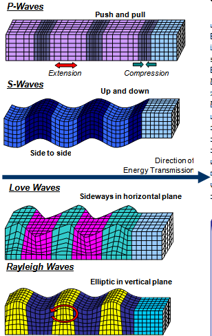
Earthquake waves:P waves - These waves are known as primary waves and are the first to be recorded by seismographs. These are fast-moving waves that do little damage. They shake the ground back and forth.S waves - These waves are secondary waves and are second to arrive. They are slower-moving waves that shake the ground back and forth perpendicular to the direction in which the wave is moving.Surface waves - These waves travel close to the surface and are the last waves. They are the slowest waves. They move the surface of the Earth up and down as well as from side to side. They are extremely devastating and are also referred to as Love and Rayleigh waves.
PREDICTIONThe main aim of earthquake prediction is to allow people time to prepare. Gas pipes can be turned off, evacuations can take place. It is important that studies be carried out in areas such as plate boundaries where earthquake activity is most active, to try to predict earthquakes. Certain building methods can be used in these regions to reduce the fatalities and damage to property.Seismologists study the history of earthquake activity. They are aware that as soon as an earthquake occurs, the pressure and tension begins to build up again.Seismologists study the patterns of earthquake activity along a fault line. By examining previous earthquakes, they may be able to say what the likelihood is of another earthquake occurring. The longer the time since the last earthquake struck, the more imminent the next earthquake.Seismologists are also interested in studying and identifying areas along the fault line that have experienced a period of inactivity. Pressure is building up in these areas and these locations could experience and earthquake in the future.A recent earthquake may also indicate a build-up of tension. e.g. when the Haitian earthquake occurred in January 2010, seismologists started to examine the building up of pressure along the fault line, as it may point to future earthquake activity.Instruments called tiltmeters are used to record changes in the level of land. Where pressure is exerted on underlying plates, a bulge or an increase in the height of the land may occur.Seismologists will also pick up any sign of disturbance, such as foreshocks. This is a tell-tale sign that a main shock is due.Animal behaviour may predict earthquake activity. Animals can behave strangely before the start of an earthquake. E.g moving to higher land.
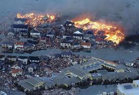
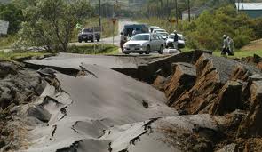
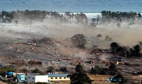
The damage caused by an earthquake depends on a number of factors:The time of the earthquake - during the day or night, during rush hourThe magnitude of the earthquakeThe depth of the focusThe distance from the epicentreThe duration of the earthquakeThe type of rocks and soils within the affected regionThe size of the populationThe building structuresThe utilities of the region e.g. gas pipes.EFFECTSLoss of life e.g. approx. 230,000 were killed in Haiti in 2010Damage to property: homes and businesses can be lost and transport disrupted.Damage to communications, such as roads, bridges, and railways. This also makes it difficult for the provision of aid.Damage to water supplyGas leaksPower cutsLiquefaction occurs where settlements are built on deep, loosely-consolidated soils or reclaimed land rather than on solid bedrock. The ground becomes liquid due to intense shaking during an earthquake. Buildings sink into the groundFiresTsunamiDamage to the sewage system - diseasesLandslidesMigration ( while damaged buildings are cleared and rebuilt)Economic slowdown.
TsunamisA tsunami is a destructive wave of water. Sometimes, when an earthquake occurs under the sea, movement on the sea floor causes ripples on the sea surface.One of the first warning signs of a tsunami can be a rapid withdrawal of water from the beach.
Ways to limit earthquake damage:The ability of a country or region to limit the effects of earthquake damage may be linked to its level of development. In a developed economy, resources are available to earthquake-proof buildings and infrastructure. Less developed or developing economies lack the money to earthquake-proof their buildings. It is important to earthquake-proof buildings in regions prone to earthquake activity. Building should be constructed of materials that can withstand the pressure of an earthquake e.g. flexible columns which allow for movement, or the insertion of rollers which allow for side-to-side mobility. Flexible materials should also be used in the construction of bridges. Fire-proofing should be considered in bridge and building construction. It is important to build on stable ground. Planning laws should be enforced to ensure that building are not constructed where liquefaction is a possibility. These laws should also make sure that building in earthquake zones have adequately built foundations which can withstand earthquake activity. It is important for countries or regions in earthquake zones to have plans in place to deal with emergencies e.g. evacuation plans should be practiced regularly and means of reducing fatalities should be researched.
Earthquakes
Prediction and effects
Videos
Want to create your own Notes for free with GoConqr? Learn more.