
14047693
Description
Flashcards by Olivia Gniadek, updated more than 1 year ago

|
|
Created by Olivia Gniadek
almost 7 years ago
|
|
| Question | Answer |
| Where do earthquakes occur | Along faults |
| What is the hypocentre | The spot within the earth where earthquake waves originate |
| What is an epicentre | Land surface above the hypocentre (focus) |
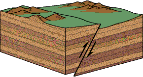
| What is a reverse fault | Along a reverse fault one rocky block is pushed up relative to rock on the other side. |
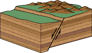
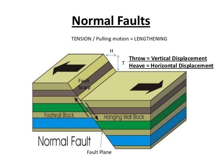
| What is a normal fault | A normal fault drops the rock on one side of the fault down relative to the other side. |
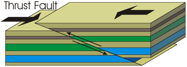
| What is a thrust fault |
Hanging wall goes up relative to footwall
Slope (dip) of fault is not steep
Image:
Thrust (binary/octet-stream)
|
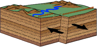
| What is a strike-slip fault | Scrape along side-by-side. Movement is horizontal Rock layers haven't been moved up or down on either side of the fault |
| What are foreshocks | A mild tremor preceding the violent shaking movement of an earthquake |
| What are aftershocks | A smaller earthquake following the main shock of a large earthquake |
| What are the two types of earthquake scales | Magnitude: The Richter Scale Intensity: The Mercalli Scale |
| What is a Mercalli scale | The Mercalli scale measures the intensity of an earthquake by quantifying the effects of an earthquake on the Earth's surface |
| What are the main plate boundary types at which earthquakes occur | Convergent Divergent Transform |
| Where do 5% of earthquakes occur | 5% of earthquakes occur in the intra-plate setting Volcanic activity that occurs within tectonic plates |
| What types of damage can earthquakes cause | Fire Liquefaction Landslides Mudslides Avalanches Ground Displacement Flooding |
| How can we predict earthquakes | On probability scales but not an absolute time scale |
| How does a tsunami occur | Caused by sudden movement of the ocean due to: Earthquakes Landslides on the sea floor Land slumping into the ocean Major volcanic eruptions Large meteorite impacts |
| How does a tsunami propogate from its source | as tectonic plates slip, energy is released into the water and travels to the surface. This displaces the water and raises it above the normal sea level. but gravity pulls it back down, which makes the water ripple horizontally. thus a tsunami is born and travels over 500 miles per hour |
| What is a volcano? | An erupting vent through which molten rock surfaces A mountain built from magmatic eruptions |
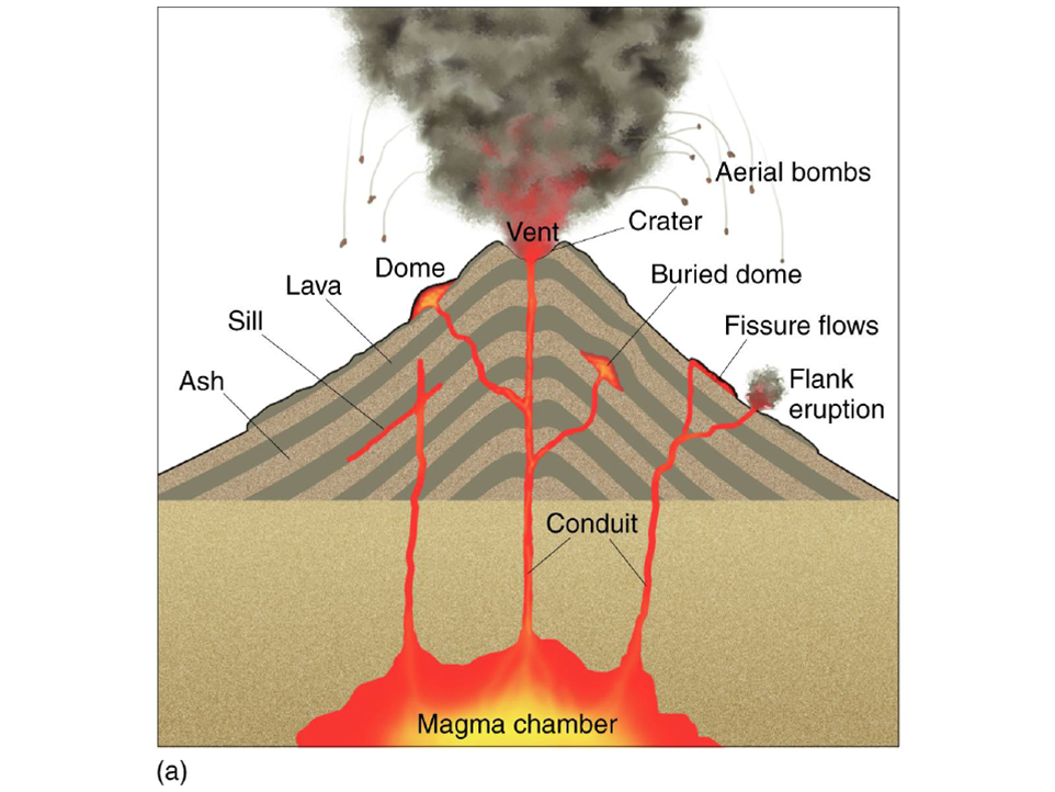
| What is the architecture of a volcano | |
| what are the products of a volcano | Lava flows - Molten rock that moves over the ground Pyroclastic debris - fragments blown out of a volcano Volcanic gases - Vapor and aerosols that exit a volcano |
| What is lava? How does it vary in physical and chemical properties | Lava can be thin and runny or thick and sticky Flow type depends on viscosity via composition Composition depends on silica (SiO2), Fe, and Mg |
| What is pyoclastic | Fragmental material ejected from a volcano Glass shards, fragmented lava in a range of sizes |
| what are the pyroclastic products | Ash Lapilli Blocks - pre-existing rock tore from the volcano Bombs - streamlined fragments of ejected lava |
| what are the volcanic gases | H2O CO2 SO2 CO H2S |
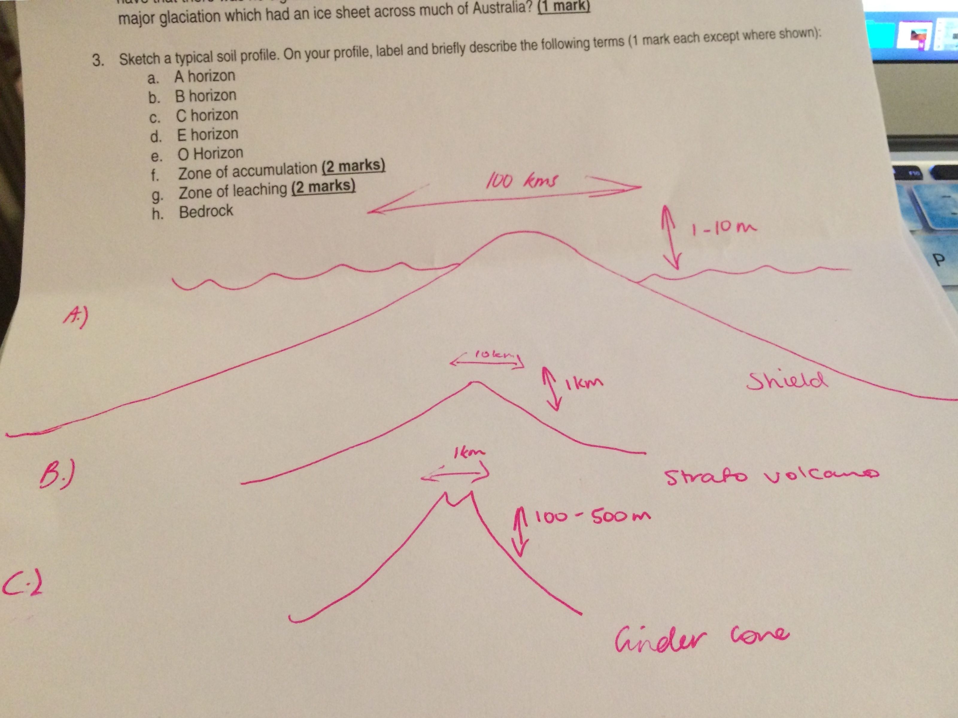
| What are the different shapes and sizes of volcanoes | Shield volcanoes - Largest Cinder cones - Smallest Stratovolcanoes - Intermediate in size |
| Sketch the shape of the different volcanoes | |
| How do effusive eruptions occur and what rock type do they form from | Lava flows stream away from vents Lava lakes can form around the vent Can produce huge lava fountains Basalt and these eruptions create shields |
| How do explosive eruptions occur and what rock type do they form from | gas pressure in the viscous magma Pressure released explosively Create stratovolcanoes Blanket landscape with tephra Andesitic and rhyolitic compositions |
| What is a phreatomagnetic eruption | magma interacts with water can be cataclysmic magma chamber breaches and admits water Water flashes to steam and blows volcano apart |
| what are the controls on eruptive style | Viscosity - controls ease of lava flow Basalt - Low-viscosity lava flows away from the vent Felsic - High-viscosity lava builds at vent |
| second control on eruptive style | Gas Pressure - Greater P favours explosive style Basalt - Low-viscosity allows gas release Felsic - High-viscosity prevents gas release |
| third control on eruptive style | Subaerial lava flowing on land cools slower Submarine lava, which is quickly quenched |
| What is an Oceanic hot spot? | Plume under an oceanic plate Basalt erupts at sea floor and forms mound Volcano builds above sea level forming island Lava builds up and out and island grows |
| What is a continental hot spot | cuts a continental plate erupts basaltic and rhyolitic material Basalt makes up mantle plume Basalt melts the granitic crust it passes through (Rhyolitic) |
| what is lava | hot molten or semi-fluid rock erupted from a volcano or fissure |
| what is tephra | rock fragments and particles ejected by a volcanic eruption. |
| what are pyroclastics | Composed of rock fragments Materials include: Obsidian Ash Pumice |
| what is a blast | a destructive wave of highly compressed air spreading outwards from an explosion |
| what are landslides | a collapse of a mass of earth or rock from a mountain or cliff. |
| what are lahars | a destructive mudflow on the slopes of a volcano. |
| what is an earthquake | sudden violent shaking of ground causing destruction, from movements within earth's crust or volcanoes. |
| what are tsunamis | long, high sea wave caused by earthquake or other disturbance. |
| what are gas emissions | Greenhouse gases trap heat from the sun and warm the planet's surface |
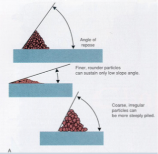
| what is an angle of repose | the steepest angle at which a sloping surface formed of loose material is stable |
| what is cohesion | component of shear strength of rock or soil |
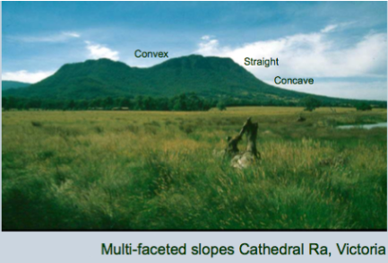
| what are the three types of slope profiles | |
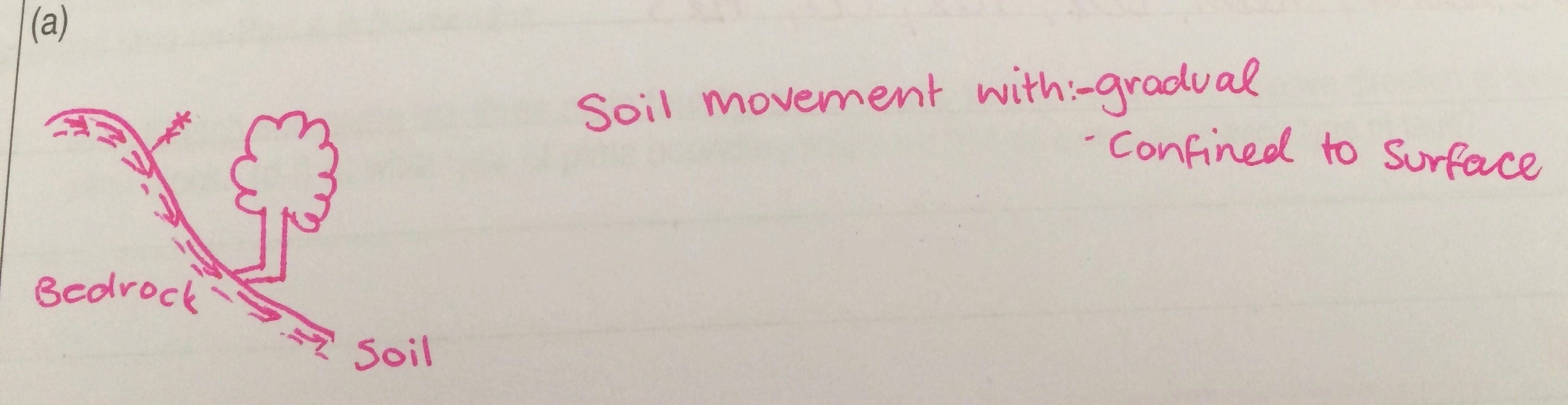
| what is a creep | |
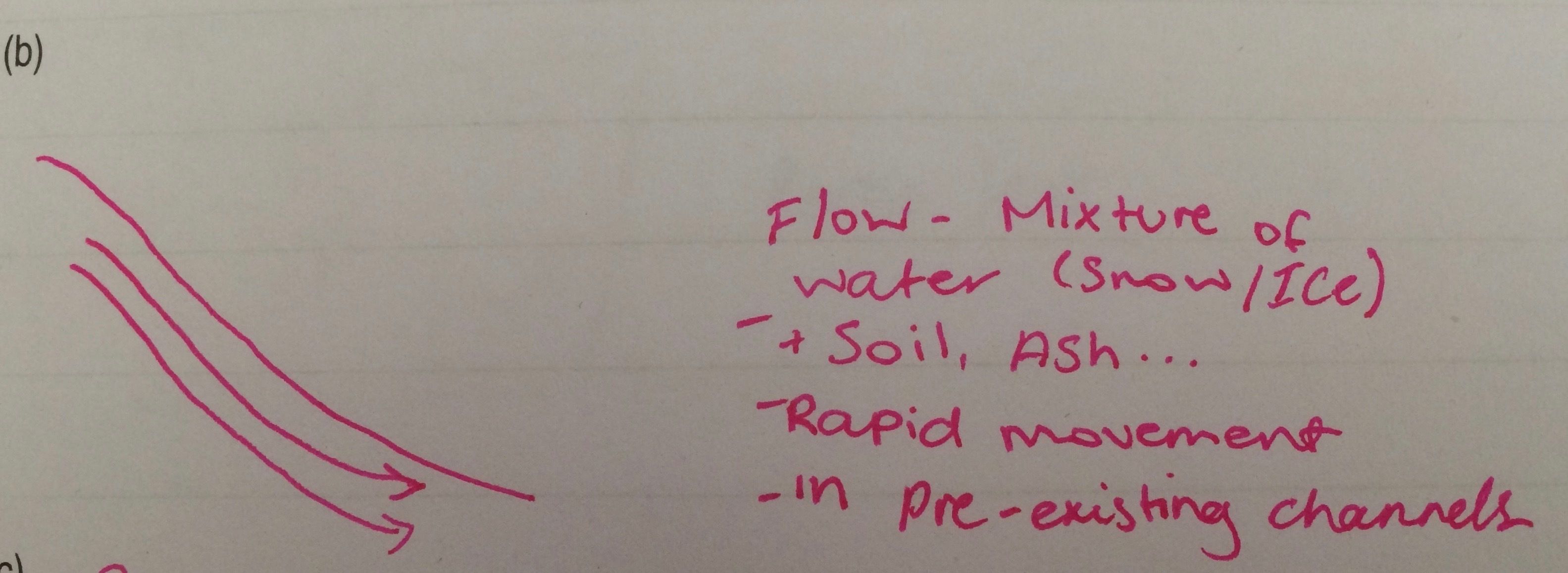
| what is a flow | |
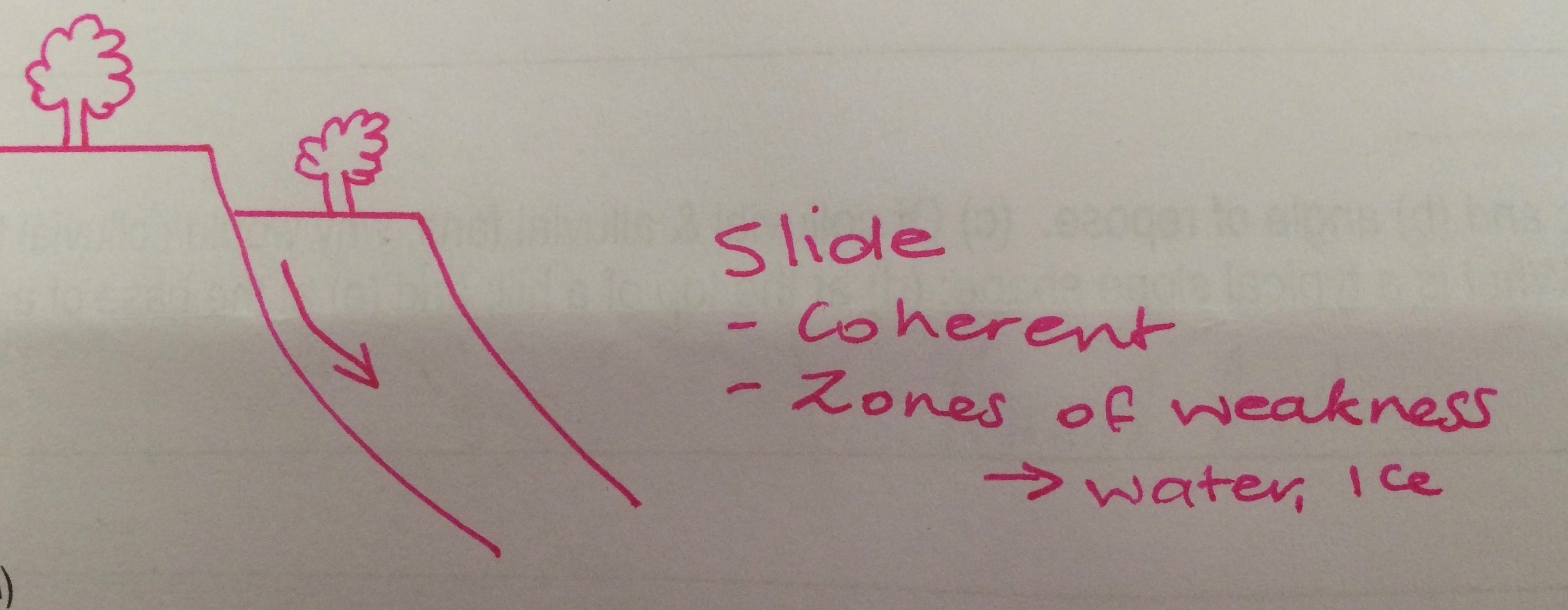
| what is a slide | |
| what is a heave | → Slope materials experience cycles of expansion and contraction (buckling) Caused by Wetting and drying Freezing and thawing Crystallisation (e.g. salt) forms patterned ground |
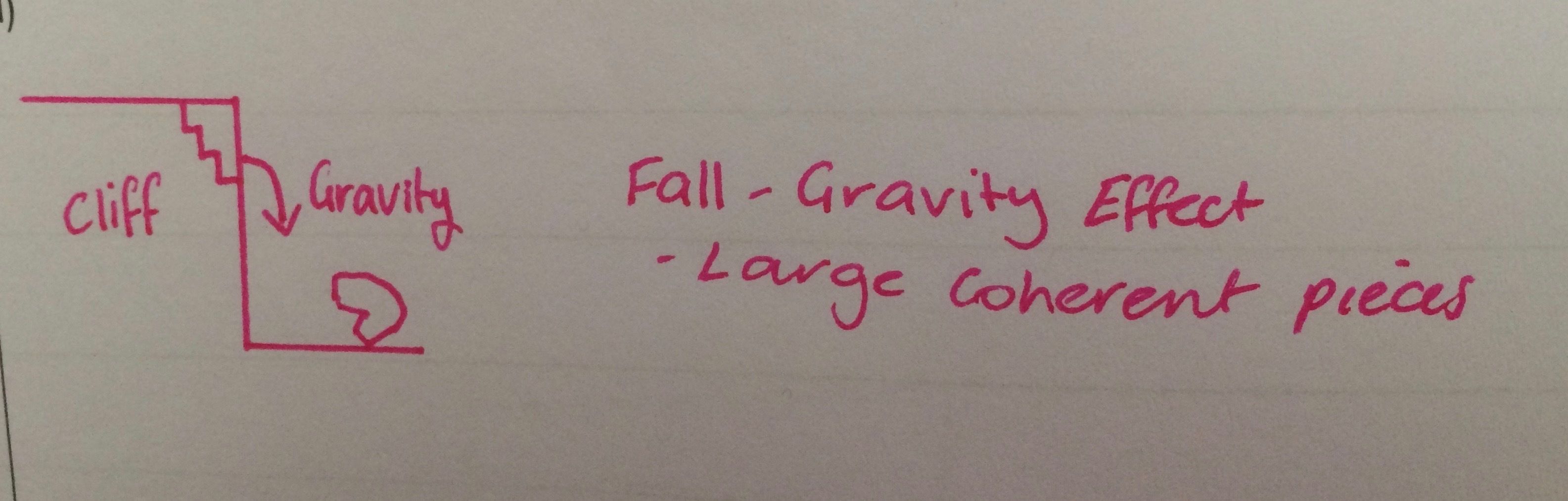
| what is a fall | |
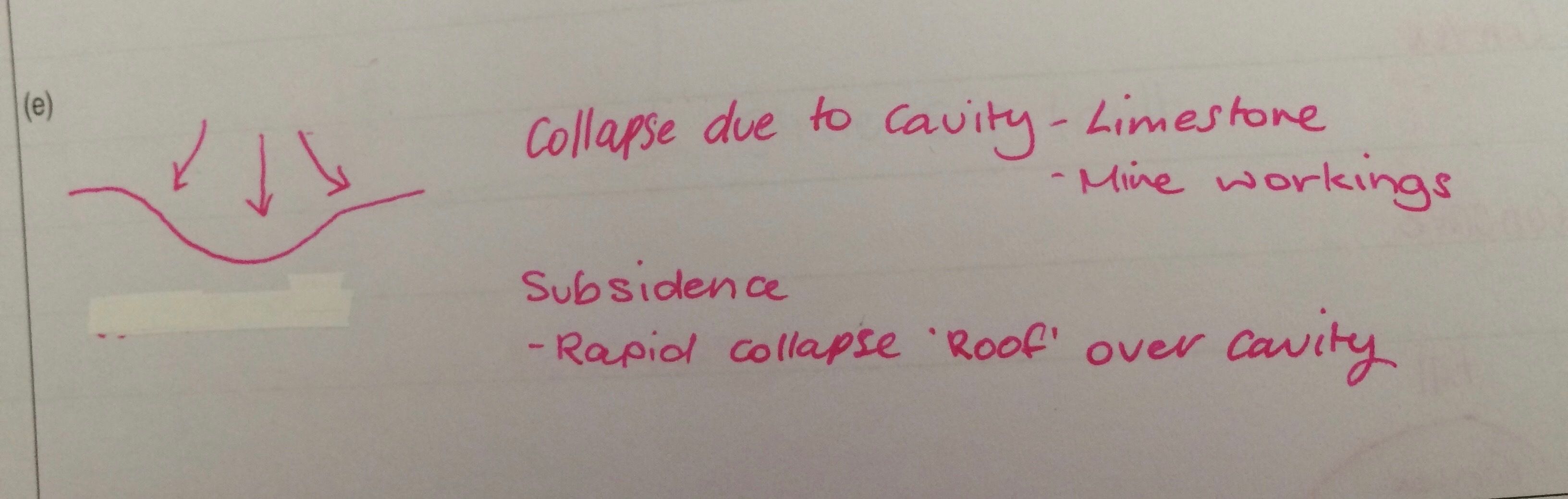
| what is a subsidence | |
| How can mass movement be predicted | Past events knowledge of vulnerable areas watch for secondary hazards |
| How do rock materials influence weathering | Weathering typically accesses a rock through water and gases Many rocks are impervious to access of these except along their surface |
| how do joints and fractures influence weathering | increase access to weathering solutions to a rock Their presence increases the potential for a rock to weather |
| What are primary and secondary minerals | Primary minerals are those that occur in the original rock Secondary minerals develop from weathering e.g. clays and oxides |
| what is mineral stability for olivine and quartz | Olivine is much less stable and chemically weathers Granite > Quartz |
| what is the process of weathering for granite | The biotite undergoes hydrolysis to form clay, oxidation forms iron oxides. Quartz will remain as residual minerals. Quartz grains may be eroded, becoming sediment. |
| what is the process of weathering for basalt | Basalt is composed of minerals with little resistance to weathering. e.g. SO2, Al2O3 Hence, basalt as a whole also tends to disintegrate faster than granite and other felsic rock types. |
| what is the process of weathering for sandstone | sandstones are composed resistant minerals (e.g. quartz) resistant features controlled by joints and fractures |
| what is the process of weathering for limestone | Dissolves in slightly acidic waters Dissolved cavities (e.g. caves) and channels are common |
| What is a regolith | Everything between fresh rock and fresh air Weathered mantle and all within it |
| what is a saprolite | Above bedrock, base of regolith (weathered) Materials, retains physical and chemical characteristics of bedrock |
| what is a weathering front | Interface between weathered and fresh materials |
| What are duricrusts | Surface, hard, indurated (water-based solution, precipitation) |
| What is the main mineral constituent for ferricrete | iron induration |
| What is the main mineral constituent for silcrete | silica induration |
| What is the main mineral constituent for calcrete | calcium induration |
| What is the main mineral constituent for bauxite | Aluminium |
| What is the main mineral constituent for gypcrete | Gypsum crust |
| What is the main mineral constituent for halite | Sodium Chloride (Salt) |
| What is a desert | low evaporation rate vegetation ground shrubs low rainfall <10'', 25cm |
| what are the five types of deserts | Subtropical - Sahara, Simpson Rain shadow - Eastern Oregon Coastal - Atacama Continental - Gobi Polar - Antarctica |
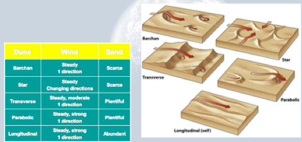
| What are sand dunes | windblown accumulations of sand |
| How do sand dunes form | Dune form depends on variation in… Wind - velocity and consistency of direction Sediment supply - Is sand scarce or abundant? |
| What are the three types of sand dunes | Transverse, parabolic and linear |
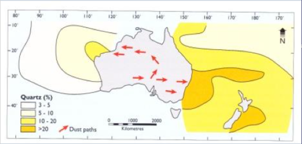
| What is the principal dust migration path across south/north Australia | *insert photo* |
| What are the main coastal interaction effects with waves and tides | Sediment movement and deposition The erosion of coastal landforms Land-derived sediment Onshore transport |
| What is swash | When a wave breaks and water is washed up the beach Constructive wave is stronger |
| What is backwash | when the water runs back down the beach Destructive wave is stronger |
| Swash and Backwash | |
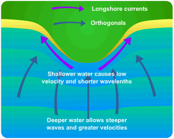
| What is refraction | Wave crest closer to shore is shallower therefore moving slower The wave crest in deeper water catches up so the wave crest tends to become parallel to the shore. |
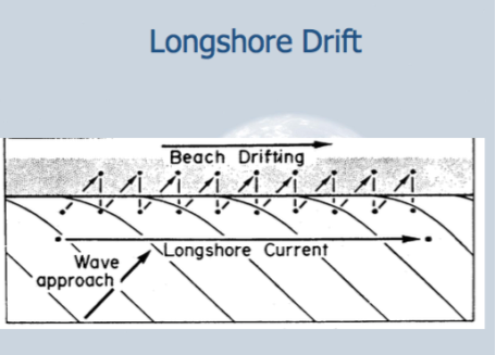
| What is longshore drift | |
| What is the main periodicity of tides and how do they form | Most coasts experience two lows and two high tides every 24 hours The moon pulls most strongly on water on the side of the earth facing it |
| What is a neap tide | When the sun and moon are pulling at right angles to each other the difference between high and low tides is minimised. |
| What is a spring tide | Tidal extremes are greatest when sun, moon and earth are all aligned, and the sun and the moon are thus pulling together. |
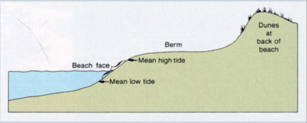
| What is a beach face and how does it form | THE BEACH FACE IS BETWEEN THE HIGH AND LOW TIDES |
| What is a berm and how is it formed | zone of vertical accretion formed by backwash deposition and its elevation is therefore limited by the upper limit of the swash |
| what is a dune profile and how does it form | Primary dunes (foredunes) are fed directly by beach sand. Dune grasses are common Secondary dunes develop through erosion of primary dunes, secondary dunes can arise from reduction in sediment supply, vegetation cover, or from increase in wind velocity |
| What are the seasonal patterns of beach development | swell waves in the summer is due to deposition from swash & beach construction, with berm development Winter storm waves cut back or completely destroy the berm eroded sediment is transported offshore into longshore bars, before returning to the beach next summer |
| What is Gondwana | Gondwana is the great southern supercontinent formed from the original Pangaea supercontinent |
| What is Pangaea | a hypothetical supercontinent that included all current land masses, believed to have been in existence before the continents broke apart during the Triassic and Jurassic Periods. |
| What is the approximate ages of breakup of Gondwana | 150 million years ago |
| What are paleo-surfaces and how long have they been preserved | ANCIENT LAND SURFACE, PRESERVED BACK TO PERMIAN |
| How do we recognise paleo-surfaces in Australia | USUALLY HIGH AREAS THAT ARE FLAT |
| What are the major phases of rifting and what are the ages of these rifts | FOR SOUTHERN AUSTRALIA, RIFTING WITH ANTARCTICA STARTED ABOUT 150 MA |
| How are rift sequences seen in the geological record of Australia | PASSIVE MARGINS, OFTEN WITH EVIDENCE OF VOLCANISM |
| What are the different plate boundaries that surround the Indian-Australian Plate | CONTINENTAL COLLISION BETWENE INDIAN AND EURASIA, MOSTLY OCEAN-OCEAN TO THE NORTH OF ASUTRALIA, DIVERGENT MARGIN TO THE SOUTH. |
| How is stress transmitted across the India-Australian Plate | TRANSMITTED ACROSS THE PLATE DUE TO COLLISION OF INDIA WITH EURASIA |
| How is Australia tilting and what are the landscape features that show this | Continental margin width, onshore marine sediments, exposed paleo-coastlines |
| Why are there no marine sediments in the Eyre Basin despite it being currently below sea level | ITS CURRENTLY BELOW SEA LEVEL BUT SEA LEVELS IN THE PAST (= CRETACEOUS AND EOCENE ) WERE MUCH HIGHER |
| What is the last major glacial event in the Permian 270 Ma | NO MAJOR GLACIATIONS IN AUSTRALIA SINCE THE PERMIAN |
| What are the other indicators of glacial events since then | SMALL GLACIAL FEATURES IN MOUNTAINS |
| Why is there little evidence of ice from the Cretaceous period, despite Australia being at high altitudes | At this time temperatures, CO2 and sea levels were higher |
| What is the K-T boundary and mass extinction | K stands for Cretaceous and T for Tertiary Caused by a 10km wide meteorite at Yucatan Peninsula, Mexico Debris from the impact caused months of darkness and cold plus acid rain therefore breaking food chain |
| Why was the Eocene a thermal maximum | there was an increased aridity as Australia has moved north |
| How do rivers and lakes react to glacial and inter-glacial events | IN GLACIAL TIMES, SEA LEVEL IS LOWER AND RIVERS CUT DEEPER INTO THE LANDSCAPE |
| What is the difference between local (tectonic) and global (eustatic) sea level change | Local changes departures from global sea-level records Resulting from local tectonics (uplift and subsidence) Global Derived from large global data sets from different settings. e.g. regression and transgression |
| What is a transgression | When sea-level rises the coast migrates inland |
| What is a regression | When sea-level falls the coast migrates seaward |
| Why was there a major sea level maxima in the Cretaceous and the Tertiary | the Cretaceous sea level high was earlier than in other parts of the globe, therefore Australia was uplifted during mid to late Cretaceous |
| How does the Eucla Basin geomorphology show significant regressions over the last 45 Ma | paleoshorelines |
| Why are paleo-shorelines across South Australia generally higher than the sea-level fall particularly in eastern Australia | RECENT UPLIFT OF THE LAND, PARTICULARLY IN EASTERN AUSTRALIA |
| How can paleo-shorelines of the coorong be shown to have regressed (moved sea wards) | SUCCESSION OF DUNES THAT GET OLDER INLAND |
0 comments
Want to create your own Flashcards for free with GoConqr? Learn more.